Saturday, December 17, 2011

Source Lake snowshoe

Now the WTA site as well as many other places say not to go here.  We checked the avalanche conditions and found they were downgraded from moderate to low.  Figured how many more days could be we be this lucky?  And no sno park pass needed once again!  So the trail head is just down the road from the commonwealth basin's.  I-90, exit 52, left from the ramp, right onto Alpental Road.  We parked in the Alpental ski area parking lot, displayed our NW Forest pass.  We decided on the main trail head start as we were thinking if the trail was blazed to the saddle up to snow lake we may just go there instead.  Started out with just treks on our boots and we strapped the shoes onto our packs.  It had snowed a little the night before, but no more than a couple of inches.  It was warmer so the snow was melting off the trees and pelting us most of the day.  We reached the split to Source and Snow quite easily, meeting only 1 other hiker along the way.(The sign you see in spring/summer/fall has been removed.)   He, too, was thinking of trying to get up to the saddle.  We followed behind him for a little, but decided to turn around when things got a little too vertical and there were no longer tracks to follow.  The risk/reward just wasn't there.  We turned back, but he seemed determined to try.  We headed back down and then proceeded to Source.  We were only 1 of 2 groups that went this way..  Once we got up to the lake, we heard and saw many alpine skiers climbing up and skiing down. We, also, saw two ice climbers!  Not to mention some snow falling very near them. We had an amazing lunch supplied by Terah: chicken sausage sliced with fresh mozzarella and roasted peppers on ciabatta bread.  AMAZING!! Washed down with a little skinny vanilla latte with the traditional whiskey chaser. We did put the snowshoes on and played around the 'bowl' area while watching all the skiers and climbers.  The skies cleared up while eating and we were able to enjoy some sunshine for a while as well as for the hike back down.  We also brought the sled.  Across the street from the ski area is a training area that has a nice long slope that isn't too steep for the best long sledding trip!!  Amazing day filled with fun.
Total miles:  5.25  (add another mile for the trips up the hill for sledding!!)
The first chute


Ice climber in the center of the big ice clump


Commonwealth Basin

Well, it's that time of year again....break out the snowshoes.  Looking around for something that didn't require a sno park pass we found the basin.  It's easy to find.  Snoqualmie Pass (our main stomping grounds) I-90 Exit 52.  Left off the ramp, under the over pass.  We parked by the ski club as there is a wide area that is plowed back.  There is a sign that states no snow play parking anywhere on Alpental Road.  It does not look official to say the least.  We were one of the first cars there at 9 AM and we decided to risk it.  We received no ticket or warning and we were not towed. We did, however, display our NW Forest Pass. Many people parked at The Summit ski area instead.  After gearing up we walked back towards the over pass and you will see the road to the parking area for the trail on the left.  Lots of people have been there before and you will where to climb up over the snow bank.  Once up the road to the trail head it is easy to find.  We followed the Pacific Crest Trail as avalanche danger was listed as green/low.  There is one particular area that would seem a danger in anything higher.  There are still signs up directing you...making it easier as well as a path that has been blazed before you.  With no new snow falling we had no problems making our way, even though we have a green trail map.  We consulted only one time when we no longer had a clear path.  Should you wish to not follow the trail, just after the entering the trail head on the left you will find the alternate route.  It is less that .25 miles in...probably closer to .15 miles or less. We did not use our snowshoes until we lost the obvious path.  Treks were all we needed and we moved along quite quickly.  The weather was very cold and the snow was incredibly crusty.  We did have to find a tree trunk to slip across to get closer to the Red Mountain and over the creek, but someone found it before us making it obvious.  Then we met up with the alternate trail.  Found a nice spot with a small waterfall with a wonderful view of Red Mountain for lunch. On the way back we followed the alternate route.  This is where we ran into droves of people and dogs.  (seeing only 2 other hikers on the way in, this was a big difference.)  Lots of people on their skis on this trail, which is something we had not run into last year.  We had a nice clear morning and after lunch the clouds started rolling in..by the ride home it started to rain/snow.  We had lots of luck in the perfect timing category today!  Terah brought a sled today and we started a new tradition....sliding after the hike.  Found a nice little hill to break it in...and we had a BLAST!

Terah provided an amazing lunch today!  Roast beef wrap with fresh basil and blue cheese!  Why does everything taste MORE amazing outside in the cold?  Oh cheese and crackers are our new side.  The latte and whiskey chaser will always stay with us!

Total miles:  6.5.  Following main trail in 4 miles to the Red Mountain.  By using the alternate route you cut off a lot of miles so the return trip was 1.5 miles.  Be aware that the alternate route is STEEP in many areas should you follow it up.
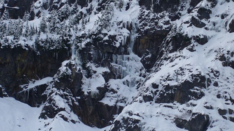


snow crystals

Natures bridge


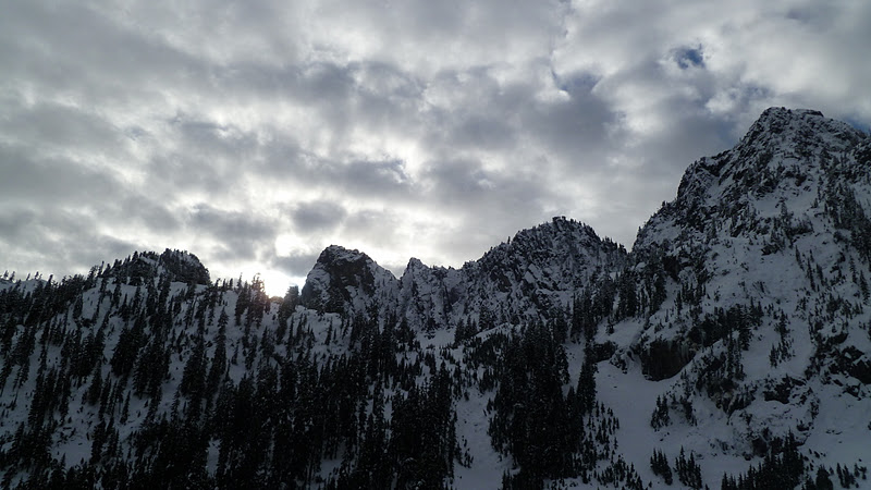
Our lunch view, not bad!


Sunday, November 6, 2011

kamikaze falls

The weather held up this weekend so we were able to get out and stretch our legs.  We weren't prepared for a nice day yesterday so we decided not to waste another great day.  We didn't want to do anything too tough as it's back to the grind tomorrow.  This is Terah's third trip to the falls this year, but she was willing to go up and check it out again for my sake.  Thanks Terah!!!  It was a total of 5.86 miles round trip and took us 3 hours with stopping to take photos and to say hello to a few groups passing by and a quick snack at the falls.  Rocks were a little lose here and there and were hidden by fallen leaves so footing had to be watched.  Nothing too difficult, but something to keep in mind.  Very cold by the falls so bring extra layers! 

Getting to the trail head is simple, just head to Mt Si and keep going.  It's on the left and is a school bus turn around.  You will need a discovery pass.  Limited parking. 


Sunday, October 23, 2011

Iron Goat

Terah and I wanted different views and we've talked about Iron Goat since last year.   We like doing a creepy hike around Halloween.  Iron Goat seemed to fit the bill.  I have to say we absolutely loved this hike.  It was easy to find our path as Terah found that Iron Goat has it's own website.

http://www.irongoat.org/hike.html

We also found the map....
http://www.irongoat.org/images/IGT2007.pdf

We went to the interpretive trail head on Route 2 at mile 58.3 on the left.  It is well marked, so no worries trying to find it. Bathrooms at the trail head.  We headed up the switchbacks to Windy point then onto the old town of Wellington.  Total miles were about 8 miles round trip.  Trail is easy to find, well marked and easy to follow.  Not a lot of people on the trail, ran into a few friendly people that made the hike that much more fun.  So happy we went, for us it was an hour and a half drive one way, but so worth the trip.  Amazing sights and great weather.  Couldn't have asked for a better Halloween hike...it is creepy in parts if you ask us!!!  Especially in  the cement snow shed!